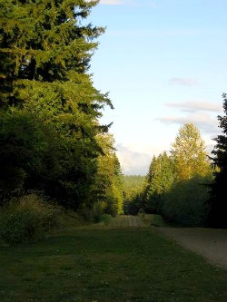
Tolt Pipeline Trail near Woodinville WA. Photo: KGilb.
2/9/2012. It was late afternoon and the sun was sinking fast. Way too fast. We only had time to walk a couple of miles before twilight fell. Unfortunately, the Tolt Pipeline Trail stretched out quite a bit farther than that, taunting us as it vanished over the top of a distant hill. I couldn’t help but wonder what lay behind that hill as we reluctantly turned around and headed back the way we had come.
The Tolt Pipeline Trail was created from the right-of-way acquired by the Seattle Water Department in the early 1960’s so they could build a pipeline. The pipeline—parts of which are still visible—carries water from the Tolt River Watershed to the City of Seattle. The right-of-way is 100 feet wide and runs approximately 12-14 miles in almost a straight line from Bothel’s Blyth Park to the outskirts of Duvall,WA.
Towering firs line the dirt/gravel access trail that dips and climbs through an ever-changing landscape. We crossed a small stream and hiked past patches of wilderness that had probably never felt the bite of a shovel. Farther along, I’m told the trail passes through a mix of wineries, breweries, equestrian estates, and some beautifully landscaped private homes. Reason enough to come back soon. And next time, we’ll start walking well before sunset!
The Tolt Pipeline Trail is well-maintained and enjoyed by hikers, mountain bikers, dog-walkers, and equestrians alike. Parking areas can be found wherever the trail crosses major thoroughfares like 216th Avenue NE and the Woodinville-Redmond Road. It can also be accessed from other trails in the area like the Snoqualmie Valley Regional Trail.
**Thanks and a tip of the hat to Seattle realtor Riley Juhl for giving me the idea for this story. Thanks, Riley!