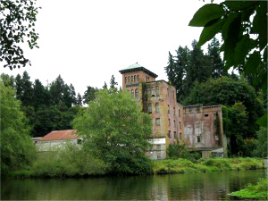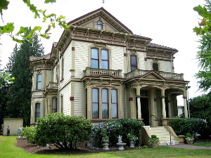
The Meeker Mansion in Puyallup WA. Photo: KGilb
Eliza Jane left the Pacific NW and traveled to Europe in the mid-1880s. It was an exciting trip for the middle-aged wife of pioneer and one time “Hop King” Ezra Meeker. The Victorian Era was in full swing and she fell in love with its distinctive architecture and ornate interior design.
Returning home to Puyallup, Washington, she decided it was time for a change. Instead of the rustic, ivy-covered, two room cabin she had shared with her husband and children for 26 years, she wanted a mansion. A Victorian mansion. And Ezra agreed that she should have one . . . as long as she was the one who paid for it!
So Eliza Jane Meeker commissioned the Tacoma architectural firm of Ferrell and Darmer to draw up plans for her dream house. Construction of the 17 room Italianate mansion continued for three years. It was finally completed in 1890 with title to the property registered in her name.
The Meekers moved in and lived there for almost twenty years, until Eliza Jane died in 1909. Shortly after her death, Ezra left the mansion and never returned. The house was then sold to the Ladies of the Grand Army of the Republic.
Over 100 years later, stained glass windows still greet visitors to the Meeker Mansion. The interior features a wealth of burnished hardwood floors, moldings, and wainscoting. Light filters in through big bay windows. Chandeliers hang from rosettes in the hand-painted and stenciled ceilings. The walls reflect the rich, warm colors of the Victorian Age. And all the rooms are furnished with antique rugs and furniture of the period, including some items that belonged to the Meeker family.
Of special interest are the six uniquely designed fireplaces with their carved wooden mantles, pressed metal inserts, and English or Italian tile surrounds.
Considering the amount of damage done by subsequent owners of the property, restoration of the Meeker Mansion borders on the miraculous. Until 1970 when the house was acquired by the Ezra Meeker Historical Society, it was used as a hospital, a retirement home, and a critical care nursing home. The beautiful woodwork and stenciled ceilings were painted over, drop ceilings installed, interior walls removed, partitions thrown up, and some of the interior doors sealed off permanently. Fire escapes were anchored to the exterior walls and, at some point, the house was sheathed in ugly asbestos siding. Fortunately, much of the damage has been repaired.
Restoration of the old mansion continues as funds become available. Recent finds include the discovery of a missing room! See article posted in The Olympian newspaper.
The Meeker Mansion is a “Must See” for anyone who loves beautiful Victorian-era houses. It’s located at 312 Spring Street in downtown Puyallup, Washington, just 35 miles south of Seattle. Cost of admission is only $4.