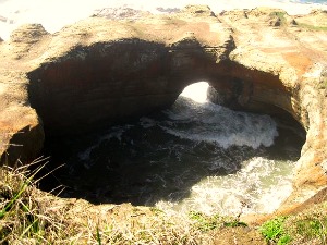
Looking down into the Devil’s Punch Bowl. Oregon Coast. Photo: KGilb.
The Devil’s Punch Bowl is a bowl-shaped rock formation found along the rugged Oregon Coast just eight miles north of Newport. When the tide rushes in, waves spill through a small hole in its base, racing around the interior walls until they get sucked back out into the ocean. The result is an angry, frothy brew fit for the devil himself.
Don’t believe me? Watch this video and I think you’ll agree.
The Devil’s Punch Bowl actually started life as two small sea caves carved out of soft rock by the relentless pounding of the waves. The caves gradually merged into one and then continued growing until, at last, the ceiling collapsed under its own weight. The collapse and subsequent erosion has created a near perfect oval shape.
Because the land here juts out into the ocean, there’s an incredible view of the surrounding seascape. A smooth, level path follows the contours of the headland, affording photographers ample opportunity to snap that perfect shot. Dozens of seabirds dot the rocks nearby. Whale spouts can be seen in season, even a sea lion or two, and it’s not unusual to see surfers and kayackers riding the waves below.
For those who want to linger, there’s also a nice little park with picnic tables adjacent to the Punch Bowl. Forgot to bring along a picnic basket? No problem. Stop by Mo’s West for some of the best clam chowder on the Oregon Coast.
The Devil’s Punch Bowl is located about 75 miles almost due west of Salem, OR. Easy to find. There’s parking on site, and the view is free!
Directions from Salem: Take OR-22W which turns into OR-18/Salmon River Highway. Continue on until you reach Highway 101/Oregon Coast Highway and turn left. Drive south about 23 miles. Watch for signs and the turnoff to the Devil’s Punch Bowl on the right side of the road.